

Donguz Orun
- Caucasus, Russia -
“The Caucasus is probably the most variegated ethnological and linguistic area in the world. It is not a melting pot, but a refuge area par excellence where small groups have maintained their identity throughout history.”
— Richard Nelson Frye, The Heritage of Persia

Figure 1. The North face of Donguz Orun as seen from Mount Elbrus. ©Sorin Rechitan, 2009
It’s been 11 years since this story unfolded, and only now did I manage to gather my thoughts to write about it. I might not remember every detail, but here goes: the story of climbing the North Face of Donguz Orun in the Caucasus.
Donguz Orun (known as the Mountain over the Lake of Pigs, 4468m) is a hallmark of the Elbrus region. It is one of the most beautiful peaks in the Caucasus Range. Its north face drops vertically into the Baksan Valley toward Kabardino-Balkaria and dominates the Cheget glade. What’s unique about this north face is its seven-shaped hanging glacier, which spills over the Baksanskoe Gorge (Figure 1). This north face both attracts and repels top climbers. A two-man team from Svanetiya, M. Hergiani and I. Kahiani, first climbed it in 1957. Since then, very few have managed to navigate its intricate system of ledges, ridges, and hanging seracs while also surviving the numerous avalanches that tend to bombard the wall every other day. Many legends surround the mountain. One says that when the Germans invaded the region in the Second World War (during the Battle of the Caucasus, 1942) and saw the seven-shaped glacier, they tried to shape it into a swastika by shooting rockets into the north face. Another legend says that once, a man descended on skis down the seven-shaped glacier. Some say that it was a Japanese, others say it was a Pole.... but no one in Russia knows his name and today this sounds like a legend.

Figure 2. Donguz Orun team: Sergiu Jiduc and Aurel Salasan. ©Sorin Rechitan, 2009
After successfully climbing Elbrus, Aurel and I (Figure 2) wanted to do something more challenging, at least from a technical point of view. Elbrus was a great ascent but also quite boring in terms of technical climbing – something which both Aurel and I loved to do. We saw Donguz Orun throughout our time on Elbrus, and frankly, I think it was in the back of both our minds: “Let’s give it a shot! That seven-shaped glacier looks way too cool!"
In Ceghet, we met a friendly individual who looked more like a mafia member than a mountain person. He owned a hotel and drove a Lexus - a very strange sight when most people who do own cars in Kabardino-Balkaria tended to drive a classic Russian Lada. This guy said he could help us get a military permit to climb Donguz for USD 100. At first we were sceptical, but after spending the whole day at his hotel and restaurant and talking with him, we realised he used to be a soldier and had re-tooled into a businessman. After working at the cable car on Elbrus, he made some money and started a small business that grew into a seasonal but successful hotel and restaurant.
The next day, he brought us the permit, granting us access to the mountain. The following day we started our adventure.

Figure 3. War remains. ©Sorin Rechitan, 2009
From Terskol we took a cable car to a stop, just before Ceghet Tau – a common training and acclimatisation peak for those wishing to climb Elbrus. From there, we followed a system of paths to a coniferous forest along the river. We zig-zagged through the forest, following the course of the river until we reached a more sub-alpine terrain, covered with large boulders. As we were jumping from one boulder to another, we suddenly saw a tank in the riverbed. It looked rather old, and after careful inspection, we realised it had been hit by some sort of rocket, maybe from the air. Quite recently, Police in Russia have found five German World War II-era artillery guns along with ammunition near the Donguz-Orun pass (Figure 3). The guns – 76-mm cannons – were in good condition, according to police. The Caucasus region is full of war remnants, not just from the Second World War but also from more recent conflicts such as the ongoing insurgency in the North Caucasus as a result of the two post-Soviet wars fought between Russia and Chechnya and Georgia's battle to regain control over its breakaway territories of South Ossetia and Abkhazia. Another interesting point in this geopolitical soup is that the Caucasus region is important for heavy industry. Rich in natural mineral resources, the extraction industry plays a key role in overall economic development (as well as conflict escalation, one might say).

Figure 4. Approaching the base of Donguz Orun. ©Sorin Rechitan, 2009
Slowly, the forest gave way to more alpine terrain, and eventually we could see the mountain's north face and the infamous glacier (Figure 4). The wall is huge! 1,500 m, but from our vantage point, right at the base of the mountain, the glacier looked quite scary! We kept going. Next, we needed to find a place to cross the icy river that separated us from the glacier. After scrambling for a couple of hours through the moraine, we found a spot that didn’t seem too deep. We took off our boots, hung them around our necks, and off we went. Oh dear, I don’t think I’ve ever experienced water colder than this. After only 3 min of being in contact with the glacial water, my feet turned red, and the pain was excruciating.

Figure 5. The outline of the route we attempted on the North face of Donguz Orun. ©Sorin Rechitan, 2009
On the glacier, we found a pair of old crampons, probably from the 1950s. They looked like they belonged in a museum, so we took them, hoping to donate them when we returned to Terskol. A couple of hundred meters from the start of the notorious seven-shaped glacier, we pitched our tent and prepared a delicious dinner. We spent the rest of the afternoon scanning the wall for a suitable route that’s avalanche-free and as direct as possible (Figure 5). Now and then we could hear or see an avalanche crumbling into the valley. There was an eerie atmosphere there, I’m not going to lie.
At 3 am we heard a loud explosion. We jumped off our sleeping bags and went outside to see what was going on. It was still dark, so we couldn’t see much, but we did feel some ‘wind’ and snow covering us and our tent. Another avalanche. We looked at each other and started laughing. Shall we do it?
An hour later, we marched decisively toward the wall. Our naivety drove us to potential death. The sun started rising just when we were climbing on the seven-shaped glacier (Figure 6). At 8, we entered the wall properly. The first hundred meters followed a system of ridges and ledges, with very poor rock quality. Everything was moving and crumbling. We kept going, and around noon, the climbing started to become more interesting: some slabs, compact volcanic rock, and exposed terrain – we were having fun! We stopped for lunch on a ledge and spent some time taking in the scenery. In front of us, Elbrus soared with green meadows at its foot, which reminded us of summer in this empire of snow and ice. Above us was a 1000m high vertical wall that we had to climb and descend safely and soundly. Everything looked unwelcoming. Huge ice cliffs, boulders, avalanches, and massive relief – but at the same time, we were in the right place. We wanted to be here, to feel the danger, to be present, to be alive!
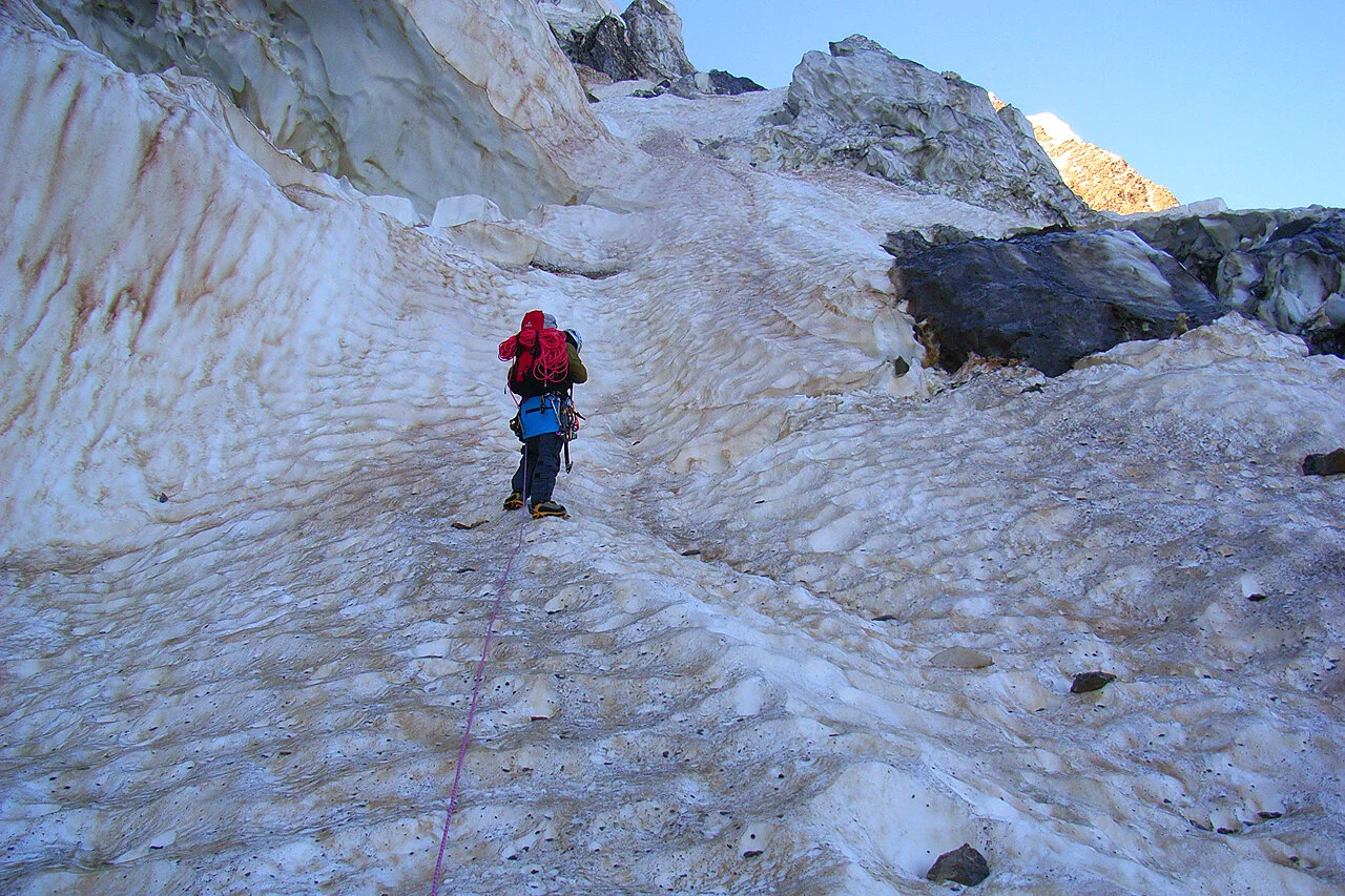
Figure 6. Aurel Salasan leading the first rope length on the notorious "seven"-shaped glacier. ©Sergiu Jiduc, 2009
After lunch, Aurel led the first rope length. When I was about to start climbing, something unexpected happened: while repacking the top of my bag, holding it between my legs to avoid nasty surprises, I heard Aurel shouting Rock, rock, rock! Naturally, I leaned left toward the wall and hoped the helmet would protect me from a potential head impact. Fortunately, the rock didn’t hit me, but my bag did get hit and with this, it leaned to the right, ‘releasing my down jacket which was compressed into a ball-shape. I didn’t see it falling, but there were huge crevasses underneath us, so most likely it got swallowed by the glacier, like many other climbing items. We had at least one bivouac to do on the wall. Not having a down jacket was not good news for my plan to cope with the cold expected at 4000m altitude.

Figure 7. Sergiu Jiduc negotiating some mixed terrain. ©Aurel Salsan, 2009
The afternoon climb was challenging. The terrain became much more technical, and fatigue began to set in. The main problem, however, was the lack of water. We had been climbing mostly on dry rock and had used up most of our supplies. Furthermore, we weren’t sure where to bivouac that night: we needed a place with some snow or water and a relatively flat area so we could get some sleep. No need to go into much detail here, but we kept climbing until midnight. I remember falling asleep while belaying Aurel – a very dangerous situation! It was quite surreal; after 15 hours of climbing, we ‘collapsed’ on a two-ledge system. We were exhausted! The next day we woke up to a sun rising to our right. In front of us, Elbrus dominated the horizon. I couldn’t remember whether or not we found snow last night. It was all quite blurry – a fine line between total exhaustion, confusion, and adrenaline-fueled movement. To my pleasant surprise, there was a patch of snow next to me (Figure 8). Unfortunately, my mattress was flat dead. I put it on some sharp rocks, which cut the material and let the air out. So, by then, I not only didn’t have a down jacket but also no functional mattress!

Figure 8. Bivouac arrangements. ©Aurel Salsan, 2009
After breakfast, we left in a hurry. We calculated that we had at least 600 m of level difference left to climb on very technical terrain. A couple of hours into the climb, disaster struck again. A plate-shaped rock fell from above, right on one of our half ropes, cutting it in half. This happened to me before on the Matterhorn the year before, but we were lucky then because a team of Czech people helped us out. Here, though, we were completely alone. After a quick assessment, we realised the best thing to do was to keep climbing, get out of the wall as quickly as possible, and find a route back to Terskol that didn’t require much abseiling. We still had one-half rope left, so in theory, we wer’t completely screwed.

Figure 9. Aurel Salasan risk-assessing the notorious ridge between Donguz Orun and Kogutai. ©Sergiu Jiduc, 2009
The day was filled with hard but good climbing, and this time, on mixed terrain. Sections of ice, snow, and rock, high up in the wall with a breathtaking view, made all our sorrows go away temporarily. In the evening, we got out of the wall and approached the summit. We still had a couple of hours of ridge climbing before the summit, so we decided to bivouac again and try to reach the peak in the morning. The ridge was very exposed to wind, which combined with the 4000m altitude, made the whole situation very cold. I sure missed my down jacket and an air mattress! To make matters worse, sometime around midnight it started snowing, and the wind intensified. Later in the night, a full-blown blizzard kicked in. It was horrible; we were completely exposed, with no tent and a very wacky bivouac site. Around 5 or 6 in the morning, the wind stopped, but it was still snowing, and visibility was very poor. A lot of fresh snow on the ridge led to the formation of very large, unstable cornices. We went on a quick reconnaissance mission to see if we could continue the ascent; however, the situation looked quite dire. We could barely see the way, and the fresh snow and cornices combined with our only remaining rope meant that a summit dash would be too dangerous. So, we decided to return to Terskol by following the ridge toward the East, walking on a fine line between Georgia to the south and Russia to the North. The ridge was full of wacky cornices, and they didn’t look solid at all. At one point, one of them completely detached, literally a couple of meters behind my partner and avalanched down the North Face of Donguz into the valley below (Figure 9). It was Russian roulette, and our survival instinct was going wild!


